Volume VII · 20 chapters
Homs
A complete 20-chapter reference volume on Homs: geography, the Orontes, Lake Qattinah and the Homs desert; the city of Homs from Emesa to the old quarters, souqs, mosques and churches; Palmyra, its oasis, temples, tombs and caravan trade; the western countryside, Wadi al-Nadara and Krak des Chevaliers; the southern, northern and eastern countrysides with Rastan, Talbiseh, Talkalakh, Al-Qaryatayn and Mahin; archaeology and tells; climate and water; economy, crafts and agriculture; society, family life, dialects, tales and cuisine; tourist routes; historical figures; Homs and Palmyra in world memory and literature; and the governorate's place at the heart of Syria.
Chapter 01
Chapter One: Homs' Natural Geography and Resources
1.1Geographical Location
Homs Governorate occupies a central position within Syria, a location that has historically endowed it with significance extending beyond its current administrative boundaries. The governorate borders Hama Governorate to the north, its eastern regions stretch towards the areas connected to Raqqa and Deir ez-Zor, while to the south it connects with the Damascus countryside and Qalamoun regions, and to the west with Tartus, the mountainous areas, and the Lebanese border. This location has made Homs a natural transit point between the country's most important axes. Travelers from Damascus to Aleppo historically passed through the Homs region, and routes from inland Syria towards the Lebanese and Syrian coasts traverse the western passes of the governorate, while eastern routes lead via Palmyra to the Euphrates and Iraq. Consequently, Homs was never a peripheral city at any significant stage of Syria's history; rather, it was often at the center of movement between regions. Control over its routes meant the ability to control a significant portion of trade and military movement between north and south, and between east and west.
1.2Area and Extent
Homs Governorate is one of the largest Syrian governorates, a fact clearly evident when comparing the distance between its green western regions and its eastern desert expanses. The governorate encompasses environments that vary significantly in climate, elevation, population density, and land use. In the west, villages are more closely spaced due to abundant water and agricultural land, while settlements become more dispersed as one moves towards the desert (Badiya), where access to water becomes a crucial factor in determining settlement locations. This vastness has made the administration of the governorate and the provision of roads and services more complex than for a small, geographically concentrated governorate, because the needs of a mountain village in the west differ from those of an agricultural town in the Orontes plain or a settlement located in the vicinity of Palmyra.
1.3Western Highlands
The western region of the governorate includes a range of mountains, hills, and valleys connected to the Syro-Lebanese mountain range and the highlands near the coast. Rainfall is higher here compared to the central and eastern regions, leading to denser vegetation and a proliferation of trees, orchards, and springs. Traditional villages in this area are characterized by the use of stone and by their architecture adapting to the slopes, with houses appearing on hillsides or along valley edges, connected by paths that follow the terrain rather than straight lines. The milder summer climate has also made a number of western areas a destination for seasonal residence and visits, while villages have retained their traditional agricultural and social identity to varying degrees.
1.4Homs Plain
The Homs Plain represents one of the most important agricultural regions in the governorate, extending around Homs city and in various directions. Its moderate topography, fertile soil, and proximity to the Orontes River and water sources have supported human settlement and agriculture since ancient times. The plain cultivates grains, vegetables, fruit trees, and various seasonal crops depending on water availability. The nature of the land also allows for easier use of transportation and agricultural machinery compared to mountainous areas. The plain was also suitable for the passage of roads, the establishment of villages, and urban expansion, which helped Homs city grow beyond its ancient center during the modern era.
1.5Orontes River
The Orontes River is one of the most significant natural elements that shaped Homs Governorate. It enters Syrian territory from Lebanon and flows northward through the Qusayr region and the Homs Plain before continuing its course towards Hama and then northern Syria. The lives of the inhabitants have been linked to the river since ancient times; it provided water for drinking and irrigation, supported agriculture and villages, and along its course, canals, water installations, and dams were built to regulate water use. The Orontes differs from many rivers in the region in its northward flow, which has been associated with the interpretation of its name in popular and geographical memory.
1.6Qattinah Lake
Qattinah Lake is located southwest of Homs city and is connected to the Orontes River and one of the oldest water regulation systems in the region. Storing water and controlling its flow were essential for achieving greater agricultural stability, especially in an environment where rainfall varies between years. The lake's water was used for irrigation, and it was also associated with fishing and local activities, becoming part of the natural landscape surrounding Homs city. The lake reveals the deep relationship between humans and water in the governorate; the environment was not merely a natural resource to be used as is, but humans intervened in it from early stages through dams, canals, and water regulation.
1.7Valleys and Springs
Springs are particularly abundant in the western and mountainous regions, and around some of them, villages, orchards, and agricultural areas have emerged. The presence of a permanent or semi-permanent spring was one of the most important factors allowing for human settlement before the advent of modern water networks. Valleys that carry water during the rainy season are also widespread, remaining dry or semi-dry during the rest of the year. In the desert (Badiya), knowledge of the locations of valleys and wells becomes even more crucial, as travelers or herders need precise information about the sources they can rely on during their journeys. Rural and desert inhabitants possessed accumulated local knowledge of water locations, seasons, the nature of wells, and the quality of their water—knowledge that was essential for life and movement before the advent of modern maps and communication methods.
1.8Rastan Lake
The aquatic area associated with the Rastan Dam and Lake constitutes another important element in the northern part of the governorate. The lake is connected to the Orontes River and the surrounding agricultural lands. Water installations have influenced the nature of settlement, agriculture, and population movement, and have also added a visual and natural element to the region that differs from the surrounding grain plains. The governorate's lakes and dams reveal the continuing importance of water management in Homs' economy, from ancient historical structures to modern projects.
1.9Homs Badiya (Desert/Steppe)
The Badiya forms the largest part of the governorate's east, extending vast distances towards Palmyra, Sukhna, and the areas connected to Deir ez-Zor, Raqqa, and the Damascus countryside. This region should not be imagined as an empty or homogeneous desert; it includes plateaus, stony plains, dry wadis, isolated mountains, salt flats, seasonal pastures, oases, and wells. Throughout history, the Badiya has been a domain of movement rather than an empty space between cities; trade and military caravans passed through it, tribes and herders moved within it, and stations, wells, and forts were established along its routes.
1.10Palmyra and the Oasis
Palmyra emerged around an oasis in the heart of the Badiya, making water the essential factor for sustained settlement within an arid environment. However, the oasis alone does not explain the city's grandeur; the Palmyrenes benefited from their location between the Mediterranean, Mesopotamia, the Gulf, and Persia, becoming intermediaries in long-distance trade. Thus, Palmyra represented the eastern face of Homs Governorate throughout history, in contrast to Homs city and the agricultural plain to the west.
1.11Summer
Summer is hot and dry in the city and the plain, while becoming relatively milder in the western mountainous regions. In the Badiya, temperatures are intense during the day, but the thermal differences between night and day can be pronounced. Traditional stone houses with thick walls and internal courtyards helped adapt to these conditions before the widespread use of modern heating and cooling systems.
1.12Livestock
Sheep, cattle, and poultry farming were widespread in different parts of the governorate, while the Badiya was particularly associated with sheep rearing and pastoralism. Animals form part of the rural economy and are not merely a source of meat, as they provide milk, wool, hides, and fertilizer. Historically, animals were also used for transport and plowing. In nomadic and semi-nomadic areas, the size of the herd represented one of the most important forms of wealth, while rainfall and the abundance of pastures determined the herder's ability to sustain animals throughout the season.
1.13Wildlife
The mountains, plains, and desert have been home to various types of animals and birds, including wild rabbits, foxes, wolves, hyenas, and birds of prey. Gazelles were historically present in parts of the Syrian desert, but the populations of several wild species have declined due to hunting, environmental changes, roads, human activity, and war. Lakes and waterways also serve as stops for resident and migratory birds, making the aquatic environment an important part of the governorate's biodiversity.
1.14The Road to Palmyra
The eastern road represents one of the most historically significant routes in the governorate. Travelers leave the agricultural lands surrounding Homs and gradually head towards a drier environment until they reach the Palmyrene oasis. This road was part of a larger network connecting the Mediterranean Sea to the Euphrates and Mesopotamia.
1.15Ancient Homs: Emesa
Ancient Homs was known as Emesa and became an important political and religious center during the Hellenistic and Roman periods. The ancient city was associated with an influential local dynasty linked to the religious establishment and the cult of the local sun god. The influence of this dynasty reached the heart of the Roman Empire, reflecting the importance of Syrian elites in the empire's political life.
1.16Elagabalus
The emperor known as Elagabalus belonged to the priestly environment of Emesa and ascended to the Roman throne at a young age. He attempted to promote the worship of his city's god within Rome, which created political and religious tensions. His reign ended violently, and his biography was subject to many negative accounts written by his opponents or historians influenced by political conflict. Therefore, reading about his life requires caution regarding the exaggerations found in some sources.
1.17Christianity
Christianity spread in Homs during the early centuries CE, and the city became an important ecclesiastical center, with churches and monasteries appearing in the city and the western countryside. The Christian presence continued after the region came under Islamic rule, forming an essential part of the governorate's social and cultural fabric. Homs retains a number of historic churches, most notably the Church of Saint Mary of the Holy Belt (Umm al-Zinnar), which holds a special place for Syriac Christians and others.
1.18Church of Saint Mary of the Holy Belt (Umm al-Zinnar)
This is one of the most prominent Christian sites associated with Homs, linked to an ancient religious tradition concerning the belt of the Virgin Mary. The church has become a destination for visits and pilgrimage, and it represents a part of the city's Syriac and Christian history. It has undergone multiple phases of construction and restoration and, like other parts of the city, suffered damage during the war before rehabilitation efforts began.
1.19The Islamic Conquest
Homs became part of the Islamic state in the 7th century CE and an important center within the administrative and military organization of Bilad al-Sham (Greater Syria). The previous demographic and cultural structure did not disappear immediately; rather, the transformation occurred over a long period. Christian communities continued alongside Muslim inhabitants, while language, institutions, markets, and urban development evolved. The city became the base for Jund Homs, one of the main military districts in the administrative organization of Bilad al-Sham.
1.20The Umayyad Period
Homs retained its importance during Umayyad rule due to its military and administrative location and the presence of a strong military contingent. At the same time, the city became involved in some of the political conflicts that characterized the Umayyad state, owing to the weight of its military and tribal groups. Agriculture, crafts, and markets continued during this period, and the roads leading to Damascus, Aleppo, and the coast remained active.
1.21Byzantine and Hamdanid Conflict
During the Middle Ages, the Homs region became part of an area that witnessed recurring conflict between Islamic and Byzantine powers. Aleppo to the north was an important Hamdanid center, while Homs served as a route and a link between different areas of Bilad al-Sham. Periods of war led to instability in some regions, while trade and agriculture resumed activity whenever routes became stable.
1.22Krak des Chevaliers
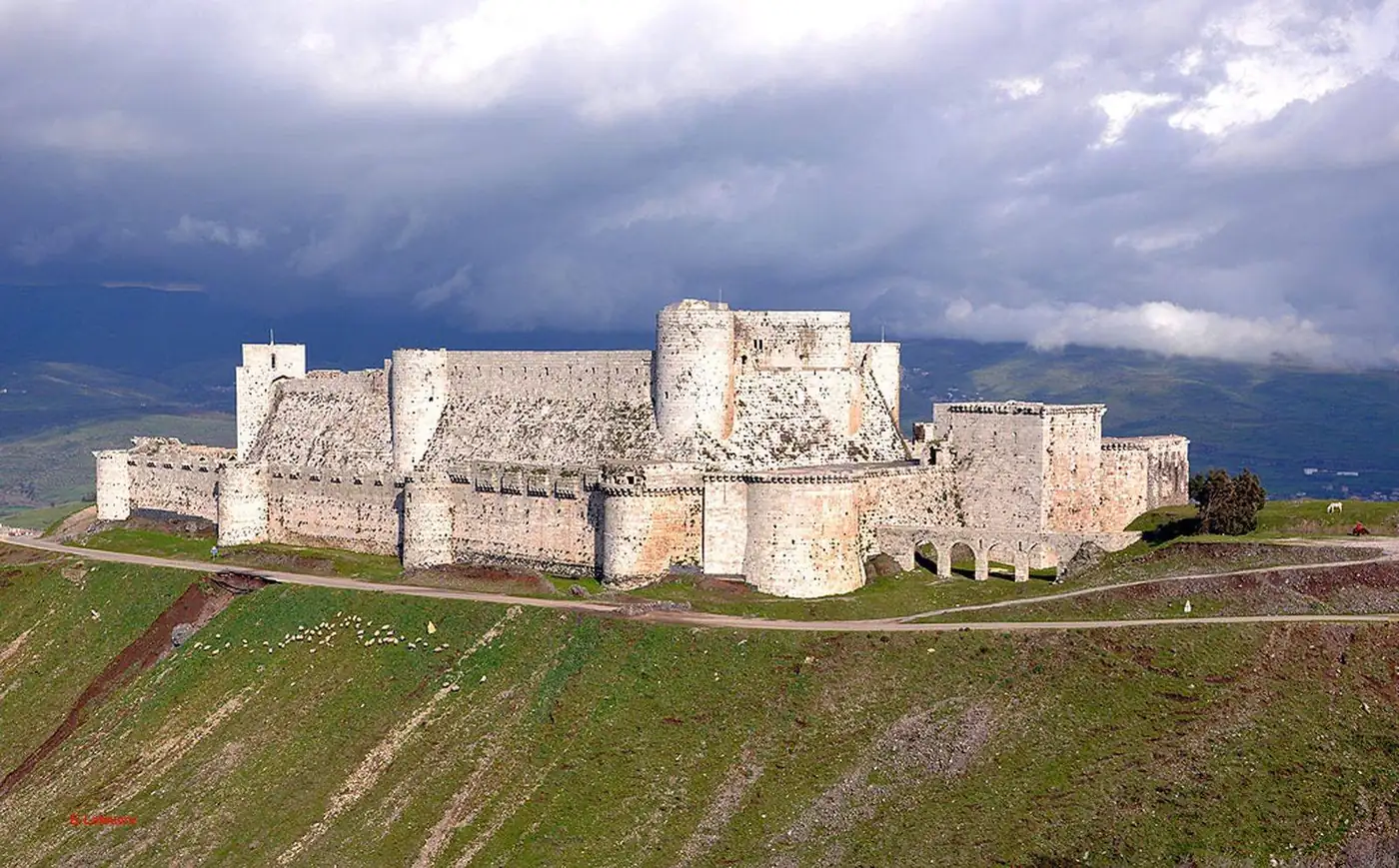
Krak des Chevaliers is one of the most famous castles in Syria and the world, located in the western countryside of Homs governorate on a high ground overlooking the passages between the coast and the interior. The castle evolved through multiple stages and came under the control of the Knights Hospitaller during the Crusader period before being recaptured by the Mamluks. It features inner and outer fortifications, towers, moats, halls, storerooms, stables, and religious and military elements.
1.23The Mamluk Period
During the Mamluk period, Homs continued to serve as a regional center connected to roads, postal services, armies, and markets. The Mamluks paid attention to castles and securing passages, and agriculture, crafts, and religious institutions continued. However, the city remained vulnerable to earthquakes, epidemics, and political problems that affected Bilad al-Sham at various times.
1.24Society in the Ottoman Era
Different religious and social groups lived in the governorate. Within the city, neighborhoods with diverse compositions emerged, while the countryside was home to agricultural villages, mountain communities, and pastoral and Bedouin groups. Markets, crafts, and trade were among the most important places of interaction between inhabitants, even as different groups maintained their own religious and social institutions.
1.25The Arab Government and the French Mandate
After 1918, Homs became part of the Arab state formed in Damascus, then came under French Mandate after 1920. The people of the city and countryside participated in national and political activities, strikes, and protests. Homs's location helped make it a point of connection between different regions of Syria. At the same time, this period witnessed the development of roads, education, and modern administration.
1.26Industrial Transformation
During the 20th century, Homs transformed into one of Syria's most important industrial centers. Industries related to oil, fertilizers, food, textiles, engineering, and others emerged, attracting workers from the countryside and various Syrian regions. This led to the city's expansion and the emergence of new neighborhoods, and the social structure gradually changed from a city dependent on trade, crafts, and surrounding agriculture to one with a broad class of workers, technicians, engineers, and employees.
1.27Urban Expansion
During the 20th century, Homs expanded beyond the confines of the old city, growing through new neighborhoods, streets, and areas. Multi-story buildings, wide streets, and cars became part of the urban landscape. Part of this growth resulted from natural population increase, and another part from the migration of rural residents to the city for work and study.
1.28The Old City During the War
Parts of the markets, neighborhoods, mosques, churches, and historic houses suffered significant damage. In some areas, the old urban fabric became a battleground, leading to losses in buildings and in the life that once thrived within them. After the fighting ceased, return and restoration efforts began to varying degrees, but restoring a building does not automatically mean restoring the community that lived in it.
1.29Palmyra During the War
Palmyra endured an extremely dangerous period during the war, with parts of its temples, tombs, and archaeological structures destroyed. The museum and site also suffered acts of vandalism and looting, while the residents of the modern city were affected by war and displacement. Palmyra became a global example of the danger that archaeological sites can face when they become part of conflict zones.
1.30Homsi Identity
Homsi identity is characterized by a clear local presence, evident in its dialect, sense of humor, food, social relations, and the memory of its neighborhoods and markets. The people of Homs are renowned in Syrian popular culture for their jokes and wit, but reducing the community to this image alone conceals the wide diversity within the governorate. Identity in Homs city differs from Palmyra, and from Wadi al-Nadara, Al-Qusayr, Al-Rastan, and the desert, yet there are links that unite the residents of these areas within the broader Homsi framework.
1.31Homs as a Key to Understanding Syria
Within its borders, the governorate encompasses layers that virtually encapsulate a significant portion of Syrian history. It contains a local Roman city whose inhabitants rose to rule the Empire, and one of the most famous caravan cities of the ancient world.
Cities in this governorate
Dalil Crafts