Volume VI · 7 chapters
Hama
A complete 7-chapter reference volume on Hama: geography, the Orontes valley and the norias; the city of Hama, its old quarters, Azm Palace, souqs, khans and bridges; archaeology from Apamea and Qalaat al-Mudiq to Shaizar, Masyaf and Tell Hama; mosques, churches, Ismaili heritage and local shrines; nature across the Ghab plain, the western mountains, Wadi al-Uyun and Jabal Shahshabu; society, crafts, dialect, cuisine and daily life; and a practical visitor guide with routes, food, seasons and responsible travel.
Chapter 01
Introduction to Hama Governorate
1.1Hama: Location and Geographical Identity
Hama Governorate holds a pivotal position in Syrian geography. It is situated at a natural crossroads between the north and center of the country, between its interior and coastal regions, and between fertile agricultural plains, mountainous areas, and the Syrian steppe. For thousands of years, this location has made it a passage for human, commercial, and military movement, a center for agricultural settlement, and a nexus connecting different Syrian regions with diverse natural characteristics, resources, and lifestyles. Hama Governorate is located almost centrally in Syria. Its area, according to the original source material, exceeds twenty-four thousand square kilometers, making it one of Syria's geographically extensive governorates. It is bordered by Idlib Governorate and parts of Aleppo Governorate to the north, Raqqa Governorate to the east, and Homs Governorate to the south, while to the west it connects with Latakia and Tartus Governorates. Generally, the governorate can be divided into several major natural environments that vary in topography, climate, and resources. To the west, the highlands associated with the coastal mountain range begin, featuring forests, valleys, springs, and mountain villages. Historically, the inhabitants of large parts of these areas relied on rain-fed agriculture and the cultivation of trees, especially olives, vines, and other fruit trees. One of the governorate's most important regions is formed around the Orontes River valley and its surrounding fertile plains. It is within this area that the city of Hama and a large number of historical settlements originated. In the northwest of the governorate lies the Ghab Plain, one of Syria's most prominent agricultural and natural regions.
1.2The Orontes River and its Waterwheels
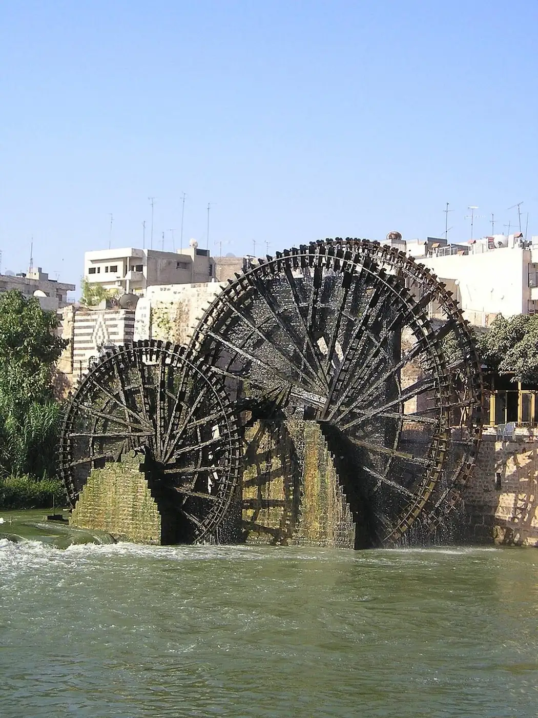
It is difficult to speak of Hama without speaking of the Orontes River. The river represents the natural element most closely associated with the city's and governorate's history, and its name has become an intrinsic part of their geographical and cultural identity. The image of Hama, both in Syria and globally, is intrinsically linked to the 17 massive wooden norias (waterwheels) situated on the Orontes River. Their primary function arose from a clear practical need: to lift river water to the level of channels that would transport it to orchards and agricultural lands.
1.3Settlement and History
Hama's significance did not begin with later historical periods. The archaeological evidence upon which this volume is based indicates human settlement in the region since prehistoric times, benefiting from water, fertile soil, and a central location. The Hama region has passed through numerous historical and cultural phases. The original material for this volume mentions a succession of Canaanite, Aramean, Hittite, Assyrian, Babylonian, Persian, Greek, Roman, and Byzantine periods before the region became part of the Islamic state in the 7th century CE. The city of Hama itself constitutes one of the most important centers of settlement in the governorate. From an early stage, it benefited from its location on the Orontes River and its ability to connect with surrounding areas. Hama entered a new phase with the transition of the Levant to Islamic rule. Over the centuries, the city became one of the region's important centers, where markets, caravanserais, schools, mosques, baths, and traditional crafts flourished.
1.4Historic Centers of the Governorate
Alongside the city of Hama, Apamea represents one of the most prominent chapters in the governorate's ancient history. There is no need here to delve into the details of the colonnaded street, buildings, and ruins, as Apamea will be one of the core focuses of Chapter Three. Shaizar is situated within the historical domain associated with the Orontes River. Its fortress and location are among the clearest testimonies to the strategic importance of routes and passages in the region. We will explore it later as an archaeological and historical site, but its presence in this introduction is essential as it reveals how geography imposed itself on history. Masyaf represents the mountainous and historical western face of the governorate. It lies on the eastern foothills of the coastal mountains, in an area naturally distinct from the Hama plain and the eastern desert. To the southeast of Hama city lies Salamiyah, situated in a transitional zone towards the desert. It is distinguished by its ancient history and the religious and intellectual role associated with it in later stages, in addition to its connection to agriculture, the desert, and cultural life. The history of Hama is not complete through its famous historical cities alone. Muhardeh, Al-Suqaylabiyah, Souran, Taybet al-Imam, Kafr Zita, Halfaya, and others represent essential components of the governorate's human geography.
1.5Economy and Society
Historically, the governorate's economy relied heavily on agriculture. Fertile lands, the Orontes River (Asi), and numerous springs supported the production of a wide array of crops. The original source refers to wheat, barley, cotton, sugar beet, vegetables, fruits, olives, pistachios, and grapes. Throughout its history, Hama Governorate has been characterized by its demographic and cultural diversity. This diversity is reflected in its dialects, customs, cuisine, architectural styles, celebrations, and social life. These distinctions become even more pronounced when comparing the city to its villages, the plains to the mountains, or agricultural areas to the desert (Badia). Like most large Syrian governorates, Hama does not speak with a single voice. There are differences between the city's dialect and those of the countryside, and between mountain villages and eastern regions. Agricultural and artisanal professions also carry their own unique local vocabularies. Historically, the village was a fundamental unit of society, its life based on land, water, family, and agricultural work. It would be a mistake to study Hama city and its rural areas as two separate worlds. The city consistently needed the agricultural produce of the countryside, while the countryside relied on the markets, crafts, institutions, and services found in the city.
1.6Hama as a Connecting Region
One of the keys to the province's history is its location between the Syrian coast and the interior. The western mountains are not the end of Hama's geography, but rather a gateway to another region. The axis connecting Damascus and Homs with Aleppo and northern Syria passes through the province, giving the city and its surroundings great importance as a station along these routes. In the other direction, a different relationship emerges. Moving eastward does not directly lead to another major city, but rather to drier areas and then to the desert (Badiyah). The Ghab Plain deserves special attention not only because it represents an agricultural land. It lies between highlands and interior regions, is traversed by the Orontes River, and its alluvial soil constitutes one of its most important agricultural characteristics.
1.7Heritage, Nature, and the Importance of Preservation
Religion forms a significant part of the governorate's history, yet it manifests in various forms. There are the historic mosques and congregational mosques in Hama city and elsewhere. Hama is characterized by the density and diversity of its archaeological sites. There are also smaller sites that do not enjoy the fame of Apamea, Shaizar, or Masyaf, but hold great value for understanding the evolution of settlement. It is essential that we do not view the mountains, river, plains, and desert as merely beautiful landscapes surrounding the antiquities. Nature itself has shaped a part of history. History is not solely about the names of kings, leaders, and battles. The recipe passed down within a family is history. Hama holds a collection of powerful images in the public memory, each representing a part of the governorate, yet none alone is sufficient to define it.
Cities in this governorate
Dalil Crafts