Volume XIV · 7 chapters
Tartus
A complete 7-chapter reference volume on Tartus: the geography of the Syrian coast, the coastal plain, the mountains, valleys and springs; history and identity; the city of Tartus, Arwad, Baniyas, Safita, Dreikish, Sheikh Badr and Al-Qadmus; archaeology and heritage from Amrit and Arwad to the Marqab Citadel, the Safita Tower and the Crusader cathedral; nature, the sea, beaches, forests and climate; society, dialect, cuisine, seafood, markets, crafts and boat-building; tourism and visitor experiences; and a practical cultural guide for visitors.
Chapter 01
Tartus Governorate: Geography, History, and Identity
Tartus governorate represents one of the most diverse areas of the Syrian coast in terms of geography, history, and patterns of human settlement. Across an area stretching from the Mediterranean Sea coast in the west to the inland hills and highlands in the east, coastal cities, ports, agricultural plains, mountain villages, forests, valleys, and springs coexist. Layered over this geography are historical periods dating back to prehistoric times, ancient civilizations, and classical, Islamic, medieval, and modern eras.
Tartus cannot be understood solely through its city. The island of Arwad represents a maritime extension with its own special historical character, Amrit preserves an aspect of the Phoenician legacy, and Baniyas represents one of the important coastal centers, while Safita, Dreikish, Sheikh Badr, and Al-Qadmus reveal a different inland world governed by mountains, forests, and the roads connecting the coast to the interior.
1.1Geographical Location
Tartus Governorate is located in the western part of Syria on the Mediterranean coast, and together with Latakia Governorate, it forms the main section of Syria's maritime facade.
Its coastal location gives it an importance that extends beyond the governorate itself, because throughout history, the sea has been a route for trade, communication, and movement, while the mountains to the east formed a passage to the Syrian interior and a natural barrier at the same time.
Historically, Tartus emerged as a city situated at the intersection of two worlds:
- ›The Mediterranean World to the West
- ›and the Syrian interior to the east
The importance of this relationship is evident in the ports, Phoenician sites, castles, ancient roads, and the distribution of human settlements between the coast and the highlands.
1.2The Coast and the Mediterranean Sea
The sea constitutes the most prominent geographical element in the governorate's identity.
The coast is not merely a western boundary of the land, but a complete economic, social, and historical environment.
The inhabitants were connected to it through:
- ›Hunting
- ›Navigation
- ›Trade
- ›Harbors
- ›Boat Building
- ›and maritime transport
Arwad Island serves as the clearest example of this relationship, forming a maritime community historically tied to navigation, fishing, shipbuilding, and the port. However, the coastal environment is not limited to Arwad.
The cities of Tartus and Baniyas, along with other coastal villages and communities, all form parts of a human and economic network connected to the Mediterranean.
1.3Coastal Plain and Hills
Between the sea and the highlands extend the lower-lying lands, where the Mediterranean climate, availability of water, and soil fostered agricultural activity.
This region forms a transitional link between the economy of the sea and the economy of the mountains.
On one hand, there are ports, markets, and cities.
On the other hand, there are agricultural lands, orchards, and villages.
Products and people move constantly between the two environments.
Thus, the coastal city was never economically separate from its rural hinterland.
Rather, the markets relied on agricultural products from the surrounding areas, while the countryside relied on the city for trade, services, and access to the port and larger markets.
1.4Mountains, Valleys, and Springs
As one travels eastward, the province's topography gradually changes.
Hills appear, followed by higher elevations, and forests, valleys, and springs increase.
Regions such as:
- ›Safita
- ›Dreikish
- ›Al-Sheikh Badr
- ›and Al-Qadmus
- ›Within this Mountainous World
Dreikish is associated with springs, forests, eco-tourism, mountain villages, and natural heritage, while Sheikh Badr is associated with mountains, forests, mountain villages, and rural heritage.
This variation in terrain led to the emergence of settlement and work patterns different from those of the coast.
1.5Forests and Water Resources
Forests, rivers, valleys, beaches, and biodiversity are essential elements of the governorate's natural environment, and these are the subjects covered in the natural chapter of the volume's original structure.
The importance of forests increases in the interior and elevated regions.
It is not merely a landscape.
Rather, it affects:
- ›Water
- ›The soil
- ›Local Climate
- ›Wildlife
- ›Rural economy
- ›and tourism
As for the springs, their presence facilitated the establishment of several rural communities and the continuation of agricultural activity.
1.6Climate and Natural Diversity
The governorate generally belongs to the Mediterranean environment, but the topography creates differing climatic conditions between the coast and the mountains.
The coast is more influenced by the sea.
While temperatures usually decrease with elevation towards the mountainous regions.
This variation leads to a clear botanical and agricultural diversity.
It also allows for diverse experiences within the same governorate:
- ›Beach
- ›Agricultural Plain
- ›Valley
- ›Forest
- ›Highlands
- ›And mountain villages
This characteristic will later become one of the most important strengths for natural tourism in Tartus.
1.7Population and Urban Distribution
The population is distributed among Tartus city, other urban centers, and coastal and mountainous towns and villages.
Settlement centers vary between:
- ›Tartus city
- ›Baniyas
- ›Safita
- ›Dreikish
- ›Al-Sheikh Badr
- ›and the villages and towns spread throughout the governorate
- ›This distribution is directly linked to geography
Coastal cities developed around trade, roads, ports, and services.
Many inland communities, however, were associated with agriculture, water, mountains, and local roads.
1.8Administrative division
The administrative organization of the governorate reflects the multiplicity of its urban and rural centers.
The presence of key areas appears to be:
- ›Tartus
- ›Baniyas
- ›Safita
- ›Dreikish
- ›Al-Sheikh Badr
1.9Beginnings of Human Settlement
There is a fundamental truth in understanding Tartus:
Human settlement here is much older than the modern city.
The presence of the sea, water, agricultural lands, and highlands provided diverse environments allowing for the emergence of human settlements at different historical stages.
1.10The Bronze Age
With the Bronze Age, the coastal picture becomes clearer, and centers associated with coastal civilizations and Mediterranean trade emerge.
The importance of this stage stems from the Syrian coast being part of a vast network that connected the Eastern Mediterranean regions with each other.
- ›Ports were not just fishing spots
- ›Rather, they were gateways for trade
The sea was a means of transport for:
- ›Goods
- ›Minerals
- ›Timber
- ›Agricultural Products
- ›and ideas
In this historical context, coastal centers began to gain importance beyond their local surroundings.
1.11Phoenician Civilization
The Phoenician legacy represents one of the most prominent components of Tartus Governorate's ancient history.
This is particularly evident in:
- ›Arwad
- ›And Amrit
Arwad stands out due to its island location and maritime identity, while Amrit is considered one of the most important sites preserving architectural and archaeological elements linked to Phoenician history in the region.
1.12Arwad and Amrit in Ancient History
Arwad and Amrit form a key axis for understanding the ancient Tartus coast.
Arwad Represents Maritime and Insular Power
Amrit, on the other hand, represents an archaeological center on the roughly opposite mainland.
Through them, one can understand the relationship between:
- ›The sea
- ›The Harbor
- ›The Temple
- ›The City
- ›and the surrounding countryside
This relationship highlights the importance of ancient Tartus as part of a wider maritime world.
1.13The Persian and Hellenistic Eras
The region, like the rest of the Syrian coast, underwent major political transformations after the early Phoenician stages.
1.14The Roman and Byzantine Eras
The Roman and Byzantine eras left significant traces throughout the Syrian coast.
This means that the governorate's history is not limited to only its Phoenician or Crusader heritage.
Rather, it contains successive layers
During these eras, the importance of the coast, roads, and cities continued, while new religious, civic, and urban structures emerged.
1.15Early Christianity
Christianity represents an important historical layer in the Syrian coast, especially during the Late Roman and Byzantine eras.
This layer later appears in churches, religious establishments, and local traditions.
The coast's location on trade and communication routes also facilitated the transfer of ideas and beliefs among Mediterranean cities.
1.16The Islamic Conquest and Islamic Eras
The Islamic conquest ushered the region into a new historical phase, and the coastal cities became part of political and economic networks connecting them to cities in inland Syria and the rest of the Eastern Mediterranean.
The importance of the coast continued due to:
- ›Harbors
- ›Trade Routes
- ›Defensive Position
- ›and maritime communication
However, control over the coast has always been of strategic importance, because whoever controls the port possesses a point of contact with the outside world.
This factor would become even clearer during the Crusades.
1.17The Crusader Wars
The Crusader Wars represent one of the most prominent periods in the historical urban landscape of the governorate.
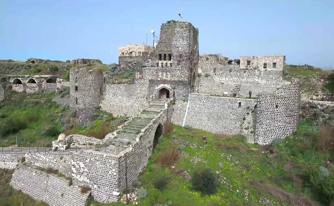
Fortifications, castles, and towers remain among the most significant elements of Tartus's heritage.
Prominent among them are:
- ›Marqab Castle
- ›Safita Tower
- ›Fortifications of Tartus
- ›And Arwad Castle
Marqab Castle, Safita Tower, and Arwad Castle are among the most important archaeological sites in the governorate.
The density of these fortifications cannot be understood without understanding the geography.
Controlling the high ground means monitoring the road.
and control of the coast means protecting or threatening the port.
Therefore, the castle and the geography appear as if they are part of a single system.
1.18The Mamluk Era
The struggle for the coastal cities and their castles was followed by a significant shift in the balance of power during the Mamluk era.
The region entered a new phase after the decline of the Crusader presence.
But the importance of defensive sites did not immediately disappear.
Castles, roads, and ports remained strategic elements, even when the powers controlling them changed.
1.19The Ottoman Era
During this phase, life continued between the coastal centers and mountain villages, and agriculture, fishing, trade, and crafts remained elements of the local economy.
The relationship between the countryside and coastal markets also continued.
- ›The farmer needs the market.
- ›and the fisherman needs the harbor
- ›and the craftsman needs a network of buyers
Through these relationships, social patterns emerged, many traces of which remain present in modern local life.
1.20Historical and Cultural Identity of the Province
If we wanted to summarize the identity of Tartus Governorate in a single element, it would not be possible.
- ›It is not merely a maritime governorate.
- ›And not just mountainous
- ›And not just Phoenician
- ›And not just a collection of castles
- ›Rather, its identity is a result of the interaction of all these elements
- ›The sea provided it with harbors, fishing, navigation, and Arwad.
- ›The plain provided agricultural land and connected cities with their countryside
The mountain provided forests, springs, villages, and defensive sites.
Its location made it a point of connection between the Mediterranean and the Syrian interior.
History left behind Amrit, Arwad, castles, towers, religious structures, and ancient cities.
Man transformed these elements into a living society.
Therefore, today, we find several layers of identity operating together within the governorate:
- ›A maritime identity among coastal communities and fishermen
- ›An agricultural identity in the countryside
A mountainous identity in the areas of Dreikish, Sheikh Badr, Safita, and Al-Qadmus.
And an urban and commercial identity in the city of Tartus, Baniyas, and other centers.
Tartus Governorate is an area where geography and history intertwine in a way that makes it difficult to separate one from the other.
The presence of the Mediterranean Sea made the coast part of trade and navigation networks since ancient times, with Arwad emerging as an important maritime center associated with fishing, shipbuilding, port activities, and marine life.
On the opposite shore, ancient civilizations left sites like Amrit, while the Roman, Byzantine, Islamic, and medieval eras added further layers of urban development and archaeological remains. To the east, the land changes from coast to hills, highlands, forests, and springs, revealing areas like Safita, Dreikish, Sheikh Badr, and Al-Qadmus within a geographical and social world distinct from the coastal cities.
Hence, the history of Tartus is not the history of a single city
It is history:
- ›Island and Port
- ›City and village
- ›Coast and Mountain
- ›Fisherman and Farmer
- ›Temple, Church, and Castle
- ›A Sea Route and a Mountain Route
Cities in this governorate