Volume IX · 7 chapters
Lattakia
A complete reference volume on Lattakia: geography, the Mediterranean coast and the coastal mountains; climate, agriculture and administration; history from Ugarit through the Roman, Islamic, Ottoman and modern eras; the city of Lattakia, Jableh, Al-Haffah, Qardaha, Slunfeh and Kasab; archaeology from Ras Shamra to the Saladin Castle; sea, forests, valleys and reserves; society, dialects, music and cuisine; and tourism across every season.
Chapter 01
Geography, History, and Identity
1.1Location, topography, and the sea.
Latakia Governorate is located in the far northwest of Syria, extending along the Mediterranean coast. It is bordered by the sea to the west, Tartus Governorate to the south, Idlib and Hama Governorates inland, and reaches the Syrian-Turkish border to the north. This location has made the governorate a link between the Syrian coast, northern Levant, and the Syrian interior. It has also given its ports and mountain passes historical significance that extends beyond its local boundaries, and this location largely explains the governorate's history. Coastal cities were not isolated from the sea, nor were mountain villages isolated from the cities. Instead, products, timber, and crops moved from the interior towards the coast, while goods, ideas, and people from other Mediterranean regions entered through its ports. Thus, a permanent relationship between the sea and the interior was forged. The sea represents the western boundary of the governorate, but historically, it was more of a pathway than a barrier. Through it, the coast was connected to Cyprus, Anatolia, Egypt, the Aegean regions, and other centers of the Eastern Mediterranean. Ugarit, in particular, reveals the ancient origins of these networks, as the kingdom in the Bronze Age was linked to various powers and kingdoms, receiving metals, textiles, oils, and luxury goods, while agricultural and artisanal products departed from its ports. Therefore, the sea is not merely a natural element in Latakia's identity; it is part of its economic, cultural, and political history. The coast stretches across the western part of the governorate, with its diverse terrain including beaches, bays, rocky headlands, ports, and river estuaries. Along this strip, the city of Latakia and other coastal areas developed, and ports and settlements emerged since ancient times. The nature of the coast is not uniform across all its areas; there are more open beaches, rocky areas, small bays, and regions where hills and forests approach the sea. This environment has allowed for the cultivation of various types of trees and crops, with citrus fruits, olives, tobacco, apples, pomegranates, and grapes being among the products associated with the governorate's different environments. The coastal lands become more than just an agricultural region when viewed historically; they provided part of the food for cities and ports, and through them passed the roads connecting the coastal cities to each other. The transition from the coast to the mountains is not abrupt in all areas. There are belts of hills, orchards, and villages that form a transitional zone between the plain and the highlands. These hills are among the environments most associated with olive cultivation, fruit trees, and rural villages. The terrain has also facilitated the emergence of settlement patterns different from both coastal cities and high mountain villages. As one moves eastward, the land gradually rises towards the coastal mountain range. These areas are characterized by dense forests, deep valleys, and abundant springs. The mountains played several roles in the governorate's history: they were a source of water, timber, a place for agriculture, home to villages, a grazing area, and a route to the interior. In some periods, they also served as a field for fortification and defense. Hence, sites like Saladin's Castle are directly linked to the mountain passes connecting the coast to the interior regions. Latakia is one of the Syrian governorates rich in vegetation cover, with pine, oak, and laurel forests, alongside springs, valleys, agricultural lands, beaches, and nature reserves. The forest density increases in parts of the northern and eastern highlands. Areas like Kassab, Slenfeh, Al-Haffah, and the mountainous countryside are associated with this green image of the governorate. However, the forest is not merely a tourist destination; it is an ecosystem, a historical resource, and a space for rural life. Historically, timber was also linked to construction, crafts, and maritime activities. Water has carved a network of valleys through the mountains and hills, contributing to the formation of the terrain. Some valleys become more active watercourses in winter and during rainy seasons, while other areas retain springs and streams. Valleys also played a role in determining natural routes between the coast and the highlands, and in fortified areas, the rugged terrain became part of the natural defense. Rain and mountain formations allow for the emergence of a large number of springs. Water has been a fundamental factor in choosing the locations of villages and orchards, as villages need water for drinking, orchards need irrigation, and animals need a permanent or seasonal source. Therefore, the distribution of a large number of mountain settlements can be understood through their relationship with water.
1.2The Climate and Natural Environments
The governorate generally experiences a Mediterranean climate. The coast is characterized by warm and humid summers and mild, rainy winters, while the cold becomes more pronounced in the highlands, where snow may occasionally fall on high peaks. However, the term "Latakia's climate" conceals significant local variations. The coastal climate is not identical to that of Slenfah; the area near the sea differs from the high peaks, and humidity, temperature, and rainfall change with altitude, orientation, and topography. The region benefits from direct marine influence, resulting in relatively high humidity and winters that are milder than those in inland Syrian areas. Summers combine heat with humidity. This climate has facilitated the successful cultivation of citrus and other crops that require suitable coastal conditions. As altitude increases, temperatures decrease, and the chances of fog, rain, hail, and snow rise in higher locations. For this reason, areas like Slenfah and Kassab have become well-known summer resorts, offering more moderate temperatures during summer compared to the coast. Slenfah is distinguished by its forests, fog, cool air, and mountain views, while Kassab is known for its forests, elevation, and relatively colder climate. Rain is one of the most crucial factors explaining the governorate's greenery. It contributes to feeding springs, forest growth, tree cultivation, and the renewal of waterways. However, rain also means that the relationship with nature changes throughout the year; a mountain road that is easy in summer may become more difficult in winter, the flow of a river or stream may change, and the forest alters its colors and density. Latakia is not just a warm coastal governorate; in the highlands, snow can fall during certain periods of winter. This is one of the images that encapsulates the exceptional geographical diversity of the governorate: the sea can be a short distance away while snow covers peaks and mountainous areas inland.
1.3Agriculture, Population, and Administrative Division
Natural diversity has led to agricultural diversity. The coast, plains, hills, and mountains do not produce the same crops in the same way. The mild climate, rainfall, fertile soil, abundance of springs, and varied terrain have made agriculture a fundamental element of the province's economy. However, agriculture here is also part of the identity: the orchard defines the village, the season dictates the work, the crop enters the food, and the product reaches the market, thus connecting geography with society. Citrus fruits have become one of the most prominent products associated with the modern Syrian coast, thriving in coastal areas with mild winters, humidity, and abundant water. Orchards are widespread in parts of the coastal plain and in areas surrounding towns and villages. Citrus is not just a crop; it is part of the visual landscape of the coastal countryside, and integral to household and agricultural economies. Olives extend across vast areas of hills, highlands, and agricultural lands. Their ability to adapt to the Mediterranean environment has made them historical trees in the region. Olives are linked to food, oil, provisions, and seasonal work, as well as to traditional presses, markets, and inherited agricultural expertise. Tobacco is among the important crops in the province, historically linked to a part of the agricultural economy in rural areas. It has become one of the crops that shaped work seasons and income for a number of families. Differences in elevation allow for the cultivation of various types of trees; what suits the coast may differ from what suits the mountains. Apples, pomegranates, and grapes are grown alongside olives and citrus. This diversity is one result of the rapid transition from the sea to the highlands. The population is distributed among Latakia city, coastal cities and towns, mountain centers, and villages. The city is diverse socially, culturally, and religiously, and has undergone demographic changes in recent decades related to migration, education, and economic transformations. Population density clearly varies between greater Latakia city and the small villages scattered on the mountain slopes. This distribution creates multiple lifestyles: the life of the port, the life of the city, the life of the fisherman, the life of the farmer, the life of the mountain village, and the life of the resort town, all contributing to the general identity of the province. There are four main administrative regions: Latakia region, Jableh region, Al-Haffah region, and Qardaha region, which include numerous sub-districts, towns, and villages that differ in their urban, social, and economic nature. Natural and cultural boundaries are sometimes more beneficial for visitors and researchers than administrative boundaries.
1.4Main Centers and the City-Rural Relationship
It is the administrative capital and the largest urban center in the governorate, combining the port, the corniche, markets, universities, cultural institutions, museums, parks, and old and modern neighborhoods. It also serves as a main starting point for other parts of the governorate. It is located south of Latakia city on the coast, merging the sea with agricultural lands and a historic city. The Roman Theater is its most prominent archaeological landmark. Jableh's history predates the Roman era, having passed through Canaanite, Phoenician, Hellenistic, Roman, Byzantine, Islamic, and medieval periods. Jableh is characterized by contemporary life continuing amidst its historical layers. It is situated at the transition point towards the mountains and forests, serving as a natural gateway to Salah al-Din Citadel, forests, springs, and high-altitude villages. Its location explains part of its historical importance: whoever controls the mountain passes can monitor movement between the coast and the interior. It lies within the eastern highlands of the governorate, surrounded by olive groves, forests, agricultural lands, and mountain villages, offering an example of the transition from the urban coast to the agricultural interior and mountains. Located in the far north of the governorate near the Turkish border, it is distinguished by forests, high elevation, a mountainous character, diverse vegetation, and a relatively cooler climate. It represents one of the most famous mountain resorts in the governorate. The forest, fog, cool air, and views are the essential elements of its image. It also provides a suitable point for understanding the history of resorts and the evolution of the relationship between cities and mountain tourism. Cities and villages were not separate worlds; the city needed rural products, and the village needed the market, services, and port. Timber, crops, and agricultural products flowed from the mountains and villages to the coast, while tools, manufactured goods, and trade items moved from the cities. In the Hellenistic and Roman eras, for example, the importance of roads between the coast and the interior increased, and villages relied on coastal markets to sell their produce. This relationship continued in various forms until modern times.
1.5Human Beginnings and Ugarit
Coastal plains, rivers, springs, caves, and protected highlands provided favorable conditions for human settlement from early periods. Early inhabitants relied on hunting and gathering, then agriculture and animal domestication developed, leading to more permanent settlements. The environment was rich in what humans needed: water, fish, timber, stone, and agricultural land. Natural passages also allowed for exchange between the coast and the interior before the emergence of major cities. With human settlement came the cultivation of grains, the raising of sheep and goats, and the manufacture of stone tools and pottery. Societies became more organized, featuring water distribution, product exchange, and labor organization. The Bronze Age witnessed a significant transformation: urban centers emerged with political, religious, and economic institutions. Maritime trade expanded, and the coast became part of a network connecting Egypt, Cyprus, Anatolia, Mesopotamia, and the Aegean regions. In this context, Ugarit rose to prominence. The ruins of Ugarit are located at Ras Shamra, north of the city of Latakia. Excavations reveal a sophisticated city with palaces, temples, residential quarters, workshops, tombs, drainage systems, and libraries of clay tablets. However, Ugarit was not an isolated city; it was the center of a kingdom based on agriculture, industry, trade, and the sea. Its influence extended to economically and politically linked regions and villages. One of Ugarit's most important features lies in the large number of discovered texts. The tablets cover various topics: trade, law, taxes, diplomacy, agriculture, religion, myths, and royal correspondence. This allows researchers to approach the details of Bronze Age society in a way that buildings alone cannot provide. Ugarit is associated with one of the oldest known alphabetic writing systems. This is why the site's importance transcends local Syrian history to the history of writing and human civilization. The city also provides information about economics, religion, architecture, international relations, and daily life. Maritime trade was a fundamental element of the kingdom's power; the coast made it part of the Eastern Mediterranean world, and through its ports, goods, materials, people, and ideas moved. Thus, from the Bronze Age onwards, a pattern emerged that would be repeated in the history of Latakia: a city on the coast linked to an agricultural hinterland on one side and to the maritime world on the other. At the end of the Bronze Age, Eastern Mediterranean cities experienced widespread transformations and disturbances that led to the collapse of several kingdoms and centers, and Ugarit was among them. However, the fall of the kingdom did not mean the end of settlement on the coast. Communities, cities, and villages continued in various forms throughout subsequent eras, and this continuity is one of the most important characteristics of the province's history.
1.6The Hellenistic, Roman, and Byzantine Ages
After the Bronze Age, the region remained part of the eastern Mediterranean coastal networks. Political and cultural powers shifted, but the sea, agriculture, and roads retained their significance. New layers of settlement emerged, often built upon older roads, cities, and resources utilized by earlier communities. Following Alexander the Great's expansions, the coast entered a new phase of Hellenistic influence. After his death, it became part of the conflict between the states established by his successors, particularly the Ptolemies and the Seleucids, before mostly settling within the original Seleucid domain. During this period, the city of Latakia emerged in a new form. Latakia was founded or reorganized during the Seleucid era as a planned coastal city, featuring the characteristics of Hellenistic cities in terms of streets, institutions, port, temples, and markets. It became part of a network of cities connecting the coast to the Syrian interior and Anatolia, with its port being a primary driver of its growth. Greek culture did not lead to the disappearance of the local society; rather, the community blended local inhabitants with Greek and Macedonian elements, as well as groups associated with trade, administration, and the military. Greek appeared in administration and inscriptions, while local languages and customs persisted. This resulted in a society with multiple cultural elements rather than a single, pure culture. The region came under Roman control in the first century BCE, and Latakia became part of a vast political and economic network. The city and coast experienced significant urban and commercial activity. Roads connected Latakia to Antioch in the north, Jableh in the south, and the interior regions to the east. These roads served as conduits for transporting goods, crops, soldiers, and travelers. The city expanded, and public facilities were established. The remnants of Roman architecture indicate an urban plan based on streets, public buildings, baths, temples, arches, and more. Jableh, in turn, witnessed significant prosperity during the Roman era, with its ancient theater remaining the most prominent testament to this period. The theater was not merely an entertainment venue but a civic institution reflecting the city's size and its capacity to construct large public facilities. Jableh was connected to its agricultural hinterland, the coast, and the road linking the region's cities. The province's economy relied on a combination of maritime trade, agriculture, the production of oil, vines, and grains, animal husbandry, pottery manufacturing, fishing, and metal and wood crafts. The port facilitated the export of products and the import of goods, while roads transported the produce of villages and mountains to coastal cities. This economic diversity would continue in various forms throughout the province's subsequent history. Christianity began spreading along the Syrian coast during the first centuries CE, becoming more prevalent as it transitioned into a recognized and then dominant religion within the Empire. Churches, communities, and bishoprics emerged, and some cities became religious centers. Monasteries played roles beyond worship, encompassing education, agriculture, book preservation, and serving travelers and the poor. Religious establishments and monastic communities spread in some mountainous and rural areas. Coastal cities continued to thrive in the Byzantine era, while the mountains saw a proliferation of villages, farms, religious structures, and fortifications. Water, climate, and arable land supported continued settlement. Simultaneously, the defensive importance of mountain passes increased with the ongoing conflicts over the coast. The Haffa area, in particular, saw the spread of villages, farms, religious establishments, and fortifications in the coastal mountains during this phase.
1.7Islamic and Middle Ages, and Castles
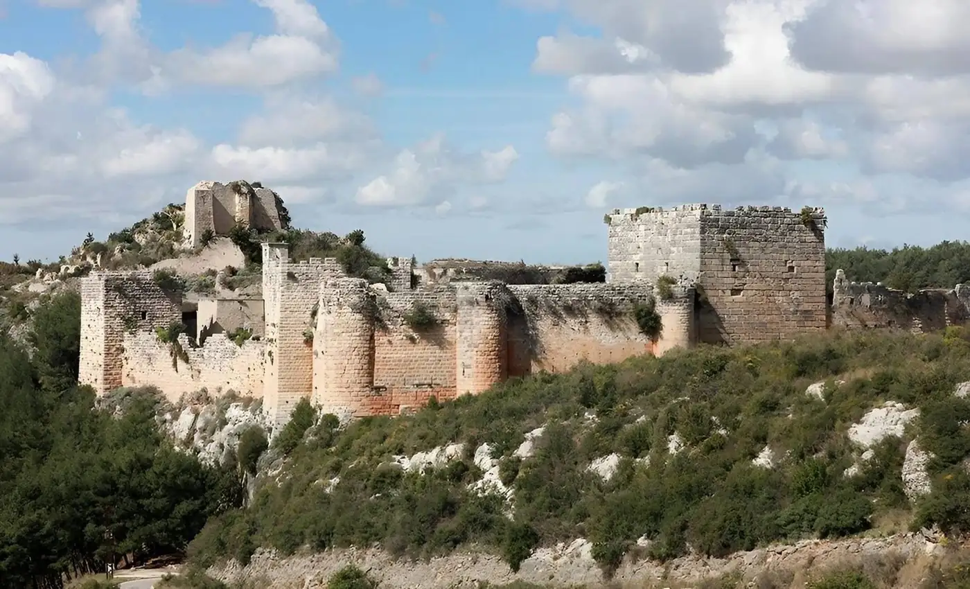
With the integration of the coast into Islamic states, a new era began. However, agricultural and rural life did not cease; villages continued to produce grains, olives, fruits, and raise livestock. Meanwhile, mountain routes and fortifications gained increasing military and administrative importance. Control over the coast changed hands multiple times due to its maritime location and proximity to conflict zones. The sea exposed coastal cities to trade and communication, but it also made them vulnerable to attacks and naval conflicts. For this reason, castles, fortifications, and elevated positions became critically important. The mountains were no longer merely a source of water and wood; they also became a defensive line and a means of controlling routes. Defensive sites linked to passages between the coast and the interior are scattered throughout the province. Among the most famous is Saladin's Castle near al-Haffah. The castle's location atop rugged terrain demonstrates how the topography itself was utilized as part of the defense, as controlling it meant monitoring roads coming from Latakia, mountain passes, coastal plains, and surrounding villages. The coast and mountains witnessed conflict between multiple powers, including Islamic, Byzantine, and Crusader forces, and castles and passes became strategic points. Yet, behind the military history, daily life continued: the farmer cultivated, the village produced, the market operated, and roads transported goods. The site began with older defensive functions, then became an important Crusader fortress before Saladin captured it in 1188. Its use and development continued in subsequent periods. The castle combines military history, engineering, and nature; deep valleys, rocks, and passes are as much a part of its defensive structure as its walls and towers. After the decline of the Crusader presence, the region remained part of the Mamluk Sultanate, and ports, roads, and castles maintained their importance to varying degrees. Agriculture, crafts, and villages also continued as the foundation of daily economic life.
1.8The Ottoman Era, the nineteenth century, and World War I
The region became part of the Ottoman Empire and remained under its rule until World War I. During this period, coastal cities and mountain villages continued to fulfill their agricultural and commercial roles, while administrative systems and trade networks changed over time. The lives of the inhabitants were not static throughout the Ottoman centuries; the region witnessed multiple economic, social, and political transformations. The sea remained a primary element, as agricultural and artisanal products needed markets, and cities required goods not produced locally. With the development of navigation and trade, the size and importance of ports changed, but the coast's function as a gateway for exchange never disappeared. The village continued to be a fundamental unit of production, yielding olives, grains, trees, livestock, and local products. The relationship between the village and the market was essential for selling surplus and acquiring tools and goods. The region, like the rest of the Levant, experienced increasing changes with the expansion of international trade, improvements in some modes of transport, and shifts in Ottoman administration. Coastal cities began to integrate more broadly into the modern Mediterranean economy, and relations between urban centers and the countryside also changed. World War I severely impacted the Latakia Governorate, as it did the rest of the Levant. Conscription, food shortages, disruption of trade, spread of diseases, and soaring prices, coupled with declining navigation, military restrictions, confiscation of some crops and animals, and difficulties in transportation in the villages, left a profound mark. Famine, emigration, and the loss of family members left a deep impact on popular memory. With the end of World War I and the collapse of the Ottoman Empire, the region entered a phase of political transition. The political future of the coast was unclear, and the Levant became an arena for competing local, regional, and international projects and powers. Then, the era of the French Mandate began.
1.9The Mandate, the Modern Syrian State, and Social Transformations
During the Mandate period, the coast experienced changing administrative and political arrangements. At certain stages, it was separated into a special administrative entity from other parts of Syria, and this phase left its mark on administration, politics, and society. Meanwhile, the development of cities, roads, institutions, and education continued. With the formation of the modern Syrian state, the governorate entered a new phase of political, administrative, and economic integration. Latakia city expanded significantly during the 20th century, with new neighborhoods emerging and the port developing. The city became a major administrative, economic, and university center. These transformations altered the city's form and its relationship with the countryside. The city was no longer confined to its historical fabric; modern neighborhoods extended, and commercial, residential, and service areas developed. The port became part of a larger national economy, and some small areas and villages gradually merged into the expanding urban fabric. The port represents a contemporary continuation of a very ancient function. Although vessels, goods, and technologies have changed, the geographical function has remained: connecting the Syrian interior to the sea. Therefore, the history of the modern port is not entirely separate from the history of ancient coastal harbors. The spread of schools and higher education contributed to societal change, and Latakia became a university and educational center. Education led to increased movement between villages and cities and to the emergence of new professions not directly dependent on agriculture or the sea. The governorate witnessed multiple forms of migration: from village to city, from the governorate to other regions, and from Syria abroad. Conversely, the city and countryside received inhabitants from different regions at various stages. For this reason, contemporary society cannot be understood as a static continuation of ancient society. Demographic changes arose linked to internal and external migration, education, and the economy. These transformations impacted: city sizes, family structures, work patterns, villages, dialects, and the relationship with the land.
1.10Continuity of place, economy, and identity
One of the most important ideas that emerges when reading the history of Latakia is that changes in power did not always mean the disappearance of inhabitants, villages, and agriculture. Instead, villages, agriculture, ports, and roads persisted, with the local community adapting to new political and economic forces. This makes the province's history as much a history of continuity as it is one of change. Civilizations change, but the sea remains, the mountain remains, valley passes remain, and spring locations largely endure. Agricultural land continues to impose its logic, which is why successive powers return to using similar sites: the port remains important because it is a port, the castle is built on a high ground because it controls the road, and the village appears near water because it needs it. It is difficult to find an aspect of the province's history where the sea does not appear, directly or indirectly. In Ugarit, it was the route for international trade; in the Hellenistic eras, the port helped the city grow; in the Roman era, it transported goods; in subsequent eras, it remained a sphere for trade and conflict; and in the modern era, the port became a major part of the province's and Syria's economy. If the sea opens the province outwards, the mountain connects it to the interior and protects its resources. From the mountain come water, timber, and some crops. Villages originated in the mountain, and castles were built on its passes. In modern times, parts of it have transformed into summer resorts and natural destinations. Agriculture is the link between geography and society. Citrus reflects the coast, olives reflect the hills and Mediterranean environment, and apples and some trees reflect the highlands. The forest provides various products and resources. Thus, the crop map is, in part, a map of topography and climate. From Ugarit to the modern port, trade exchange appears as a recurring element. The economy of the Ugaritic era depended on maritime trade and the export of timber, oil, agricultural products, and more. Then markets and crafts expanded in Islamic eras, and ports, commercial agriculture, and food industries developed in the modern era. This shows continuity in function, even when goods and economic systems differ. Coastal identity does not just mean living near the shore. It is a set of relationships: with the sea, humidity, fishing, the port, agriculture, food, trade, and even the way some areas are built. This is more evident in Latakia city, Jableh, and coastal villages. In the mountain, life changes: distance, altitude, weather, crop type, village shape, and the relationship with the road. Different environments appear in Haffeh, Kassab, Slenfeh, Qardaha, and their surrounding villages. But the mountain does not exist in isolation from the coast; the economic and social relationship between them is ancient. The countryside includes farmers, orchard owners, livestock breeders, artisans, and workers who move between village and city. This identity has changed with education, roads, cars, migration, and modern work, but the land and the season remain important elements in many areas. The urban identity is concentrated especially in Latakia city and Jableh, and is shaped by: the market, the port, the neighborhood, the university, employment, the café, the corniche, cultural institutions, and commercial life. It is a modern and ancient identity at the same time, because the contemporary city is built upon a long urban history. The province is characterized by its social, cultural, and religious diversity, which reflects its long history. The most important thing is understanding how communities lived within a shared geography, using the same markets, roads, land, and cities, and exchanging products, customs, and vocabulary. The difference between the coast, mountains, villages, and cities led to local variations in speech; frankly, the diversity of the terrain was reflected even in local dialects. However, dialects have changed with education, media, migration, and daily movement. The coastal and mountain cuisine reflects what the environment provides: fish is linked to the sea, olives to the land, vegetables to orchards, herbs to the countryside, and animal products to villages. But cuisine is not a static copy of the past; it constantly changes with markets, migration, and modern tastes. Architecture varies according to the environment: in the city, urban buildings, markets, and neighborhoods appear; in the village, the relationship between house and land is evident; and in the mountain, terrain, local materials, and weather influence construction. Castles, on the other hand, use rock and height as part of their defense. Thus, geography can be read in the shape of a building. The road is an essential element, yet often invisible in history books. Without roads, timber would not reach the port, crops would not reach the market, armies would not move towards the castle, and families would not travel between village and city. The port is the maritime face of the road; it is the place where land movement transforms into sea movement. From ancient Ugarit to modern Latakia port, the form of the port has changed drastically, but its primary function has remained to connect the region to the outside world. The market is the meeting point of the sea, mountain, countryside, and city. Fish arrives from the coast, oil, vegetables, and fruit from the countryside, goods through trade, and people from neighborhoods and villages. Therefore, studying the market helps understand society more than the simplicity of the place might suggest. Forests were a resource, but also an environment for life: wood, plants, pasture, water, shade, and a place for villages. In modern times, they have also become a destination for visits and tourism. This transformation from a "resource" to a "resource and destination" requires management that preserves the environment. The emergence of summer resorts like Slenfeh and Kassab represents a relatively modern stage in the residents' relationship with the mountain. The mountain, which was an environment for work and settlement, also became a place visited by city dwellers escaping the summer heat and coastal humidity. Thus, a new economy emerged based on accommodation, services, restaurants, and seasonal movement. A similar transformation occurred on the coast. The beach is no longer just an area for fishing, the port, and work; it has also become an area for recreation, swimming, and tourism. With this new use, facilities and services have emerged, and some parts of the coast have changed. No less important than archaeological heritage are ancient forests, valleys, springs, rocky headlands, beaches, and marine ecosystems, all of which deserve protection and documentation, as environmental loss can be irreversible, much like the loss of an archaeological site. The province possesses sites that encapsulate different stages of its history, and a fundamental group helps read this history: Ugarit for the Bronze Age, writing, and international trade; Ras Ibn Hani for coastal ports and palaces; Latakia city for urban continuity from the Hellenistic and Roman eras to modern times; Jableh for the ancient coastal city and Roman theater; Saladin Castle for the history of fortifications and mountain conflict; Haffeh for the relationship between the town, the castle, and mountain roads; and Kassab and Slenfeh for the environmental, rural, and tourist history of the highlands.
Cities in this governorate