Volume VII · 7 chapters
Al-Hasakah
A complete reference volume on Al-Hasakah: geography, the Khabur and Jaghjagh rivers and the Syrian Jazira, the city of Hasakah and the towns of the governorate, the great archaeological tells of Tell Halaf, Tell Brak, Tell Leilan and Urkesh, nature and landscape, cultural, religious and local life, tourism and visitor experiences, and a practical cultural guide.
Chapter 01
Al-Hasakah Governorate: Geography, History, and Cultural Identity
1.1The Location of Al-Hasakah Governorate in Syria
Al-Hasakah Governorate is located in the far northeast of the Syrian Arab Republic, forming the most prominent Syrian part of the geographical region known as Syrian Jazira. Its location in the northeastern corner of the country gives it a distinct geographical character, as it connects with the Syrian interior on one hand, while its external borders extend alongside Turkey to the north and Iraq to the east and southeast, which historically made it part of a vast transit and communication zone between the Levant, Mesopotamia, and Anatolia.
Al-Hasakah is distinguished by its vast area compared to many other Syrian governorates, and by the prevalence of open plains, archaeological tells, watercourses, and relatively distant cities. Therefore, the governorate cannot be understood through the city of Al-Hasakah alone, but rather must be viewed as an integrated geographical region within which urban centers, archaeological sites, waterways, and diverse natural areas are distributed.
The governorate's location is one of the key factors in understanding its historical importance. The area between the upper Tigris, the Khabur basin, and the routes leading to the Euphrates and Anatolia has been, since ancient times, part of a vast network for the movement of people, goods, and ideas. This led to the emergence of early human settlements there, some of which later developed into important cities, political, religious, and commercial centers.
1.2Al-Hasakah and the Syrian Jazira
The name Al-Hasakah is geographically linked to a broader concept: the Syrian Jazira, which is the region located in northeastern Syria within the upper extension of Mesopotamia. The word Jazira here does not mean land surrounded by water in the direct modern sense, but rather relates to the historical designation of the region situated between major river systems and their tributaries.
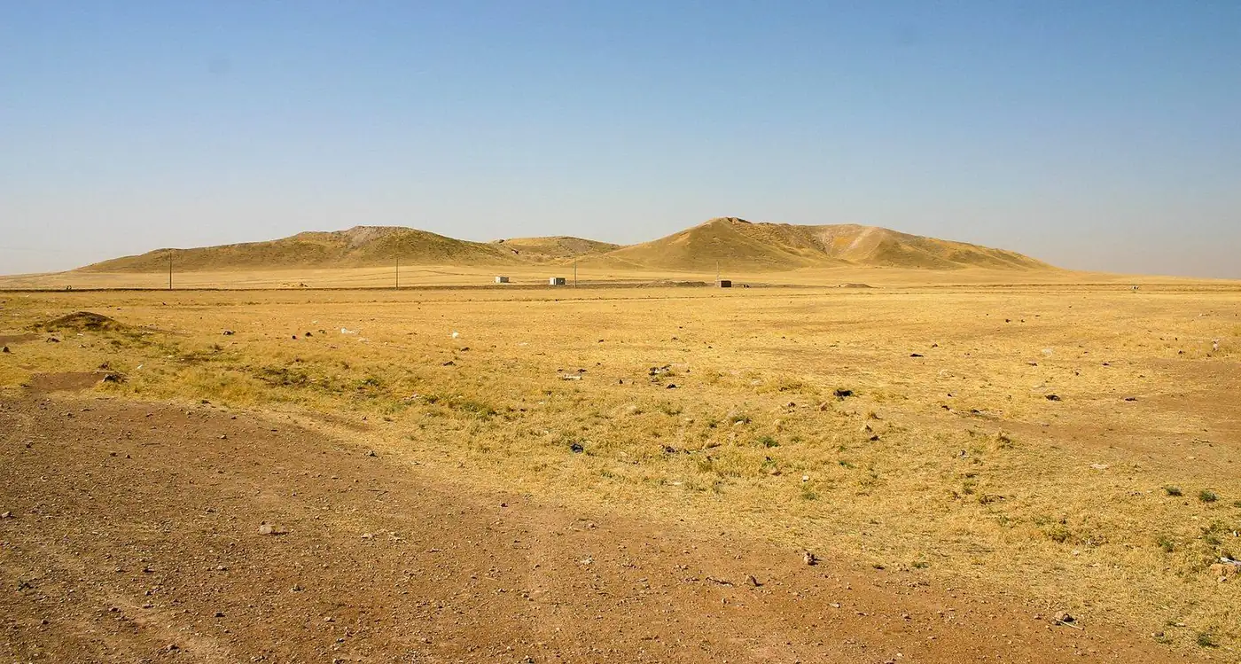
The nature of Al-Jazira differs from the Syrian coast, the western mountains, and the inner desert (Badia) regions. The landscape here is more open, the horizon wider, and plains are more prominent, while archaeological tells appear in various parts of the land as if they are scattered markers containing accumulated layers of human settlement.
This relationship between open land, water, and ancient tells gives Al-Hasakah Governorate one of the most distinctive geographical characters in Syria. Within relatively short distances, one can move from a modern city to a river or a wide plain, then reach an archaeological tell that conceals the remains of a city that flourished thousands of years ago.
1.3Borders and Location between Syria, Iraq, and Turkey
Al-Hasakah's border location has contributed to the formation of its character throughout history. Modern political borders have divided a geographical area that, over long historical periods, was more interconnected economically, socially, and culturally.
To the north lie the current Turkish territories, while the east opens to northern Iraq and the upper regions of Mesopotamia. From the west, the governorate connects with the internal areas of northern Syria, while to the south it is linked to the regions leading to the Euphrates Valley.
This location made Al-Hasakah a meeting point for several major historical regions. Through these routes, trade, ideas, architectural styles, religious traditions, languages, and cultures were transmitted over thousands of years.
Therefore, the study of Al-Hasakah should not be conducted by considering it a peripheral area far from historical centers, but rather as a region that, in many stages, was close to the heart of communication networks between the Levant, Mesopotamia, and Anatolia.
1.4The Khabur River
The Khabur River represents one of the most important geographical and historical elements in Al-Hasakah Governorate. The river and its basin were not merely a source of water, but also formed a central axis that contributed to determining settlement locations, routes, and human communities since ancient times.
Along the Khabur basin, numerous archaeological sites and human settlements emerged, making the river an essential element for understanding the historical map of the governorate. Ancient humans needed water, but they also needed suitable land for settlement and routes that allowed communication with other communities, and the Khabur basin provided an important combination of these elements.
The river's relationship with the urban and natural landscape remains evident in different parts of the governorate. Therefore, the Khabur will appear repeatedly in subsequent chapters, sometimes as a natural element, sometimes as part of the history of cities, and other times as an axis connecting a number of archaeological sites.
1.5The Jaghjagh River
The Jaghjagh River is one of the important watercourses in northeastern Syria, and parts of the governorate's geographical and urban landscape are associated with it. Although the Khabur usually receives more attention when discussing the geography of Al-Hasakah, understanding the region's water network requires viewing the Jaghjagh and other tributaries and watercourses as parts of a wider water system.
These watercourses influenced the selection of settlement sites and the formation of some urban and natural landscapes. Moreover, changes in water flow over time illustrate the local environment's sensitivity to natural and human factors.
1.6Plains, Plateaus, and Semi-Arid Regions
Vast parts of Al-Hasakah Governorate are dominated by open plains, yet the natural landscape is not entirely homogeneous. There are differences in elevation, land type, watercourses, and vegetation cover, in addition to drier areas and others historically associated with water sources.
The plains give the governorate a wide visual horizon that clearly differs from the mountainous landscape in western Syria. Archaeological tells stand out prominently across this land, making them distinctive elements in the natural landscape even before their historical value is known.
Many of these tells are not entirely natural formations, but rather the result of accumulated layers of construction, destruction, and re-settlement over long periods. Thus, the geographical landscape itself becomes an indirect record of human history.
1.7Climate and Seasons in Al-Hasakah Governorate
Al-Hasakah Governorate's climate is distinctly continental, influenced by its interior location, relatively far from the direct impacts of the Mediterranean Sea. This character is evident in the noticeable differences between summer heat and winter cold, in addition to seasonal variations that change the appearance of the plains, watercourses, and the governorate's general natural landscape.
Summers are hot and dry throughout most of the governorate, with heat intensifying in open and low-lying areas, while early mornings and evenings become more suitable for outdoor activity. The nature of the vast plains and the scarcity of topographical barriers affect the perception of the climate, as the land remains exposed to sunlight and winds for long distances.
Winters, on the other hand, are cold compared to many Syrian regions, especially during the night and in the northern areas. Rainfall occurs mainly during the colder half of the year, transforming the colors of the land and making the natural landscape distinctly different from its dry summer appearance.
Spring represents one of the most visually distinct seasons, as parts of the plains turn greener after the rainy season, and outdoor excursions and visits to natural and archaeological sites become more comfortable when temperatures are moderate.
Therefore, understanding Al-Hasakah's climate is not limited to knowing temperatures, but also helps explain the environment's shape, the nature of rivers and seasonal watercourses, and the varying experience of the place from one season to another.
1.8Water and its Role in Shaping the Geographical Domain
The history of Al-Hasakah Governorate cannot be understood in isolation from water. In a region that ranges from plains to semi-arid areas, rivers, springs, and seasonal wadis acquired exceptional importance in determining the locations where humans were able to settle for long periods.
The Khabur River and its tributaries, along with the Jaghjagh River and springs scattered in some areas, formed a water network that was linked to the emergence of numerous human settlements. When the archaeological map of the governorate is read alongside the hydrological map, the close relationship between a large number of ancient sites and water sources or routes leading to them becomes apparent.
Water was not only a factor for settlement but also became part of the place's identity. Rivers divide the landscape and connect its parts at the same time, appearing in the memory of cities, in the locations of bridges and gatherings, and in historical photographs of the governorate.
Some characteristics of this water network have changed over time due to natural factors, human intervention, and changes in water usage patterns. Therefore, the landscape a visitor sees today does not necessarily represent the same image the region knew in ancient historical periods.
1.9The Khabur as a Historical Hub for Settlement
If the Khabur River represents one of the most prominent natural features in Al-Hasakah today, its historical importance is much deeper. Its basin provided conditions that facilitated the establishment of a series of ancient settlements and centers, becoming one of the axes through which the development of human settlement in northeastern Syria can be read.
On both sides of the river and within its basin, archaeological mounds of varying sizes are scattered. This distribution reveals that the region was not composed of a single isolated urban center, but rather a network of settlements interconnected by varying degrees of economic, political, and social relationships.
Tracing these sites allows for an understanding of how humans transitioned from small gatherings to more complex centers, and then to cities that possessed religious, administrative, and defensive structures. For this reason, the Khabur Valley represents an important area for studying the history of the emergence of urban societies in the region.
1.10Archaeological Mounds as Part of the Natural Landscape
One of the most striking features of Al-Hasakah Governorate is the abundance of archaeological mounds. Some may appear to the untrained eye as mere natural elevations in the middle of the plain, but a large number of them were formed by the accumulation of successive layers of human settlement.
When a settlement was built and then subjected to demolition, fire, or abandonment, new buildings were often erected on top of the remains of previous structures. With the repetition of this process over hundreds or thousands of years, the ground level gradually rose until the mound we see today was formed.
For this reason, an archaeological mound can be viewed as a layered archive. Each level may belong to a different period and may contain buildings, pottery, tools, seals, burials, and artifacts that help researchers reconstruct aspects of the life of the communities that inhabited the site.
Al-Hasakah is distinguished by the presence of a number of mounds that have gained global fame in archaeological studies, foremost among them Tell Brak, Tell Mozan, Tell Leilan, Tell Halaf, and Tell Beydar. However, these major sites represent only the most famous part of a much broader archaeological map.
1.11Beginnings of Human Settlement
Al-Hasakah's historical importance is linked to the depth of human settlement within it. The environment surrounding the rivers and plains provided conditions that allowed for the establishment of stable communities from very ancient times, and these communities then developed over time.
This development should not be imagined as a sudden transition from a simple life to large cities, but rather a long process during which expertise accumulated in construction, spatial organization, resource storage, division of labor, and management of relations among inhabitants.
With the growth of some settlements, the need for more complex societal organization emerged. Architecture and archaeological finds reveal differences in functions within some sites, and the existence of structures that went beyond simple domestic use.
From this, Al-Hasakah gains special value in studying the stages that preceded the emergence of major cities, and then the stages that witnessed the growth of those cities and their transformation into influential centers in their surroundings.
1.12From Village to City
One of the major stories that can be read through the archaeological remains of Al-Hasakah Governorate is the story of the development of human agglomerations from small settlements to organized cities.
The ancient city was not just a larger collection of houses. The emergence of a city implies a higher degree of organization, public or religious spaces, professional specializations, systems for storage and administration, and economic relations connecting inhabitants to surrounding areas and perhaps to distant regions.
The governorate's sites offer different models for this process. In some mounds, traces of long urban expansion appear, while other sites reveal religious or political centers that acquired importance extending beyond the limits of the settlement itself.
Thus, the study of Al-Hasakah's sites becomes part of a broader question in archaeology: How did cities emerge, and how did the relationship between humans and place change when human settlements became larger and more complex?
1.13Tell Brak and the Beginnings of Urbanization
Tell Brak holds an exceptional position in the study of the history of ancient cities in northern Mesopotamia. Archaeological research has shown that the site witnessed early stages of growth and settlement, and its importance extends back to very distant periods in time.
Architectural discoveries and diverse artifacts help in understanding some aspects of the social, religious, and economic organization that characterized the site. Among the most famous elements associated with Tell Brak is the so-called Eye Temple, which acquired its name from the large number of small statues with prominent eyes found in its archaeological context.
The importance of Tell Brak lies not in a single artifact or structure, but rather in the site's ability to provide a long record that helps researchers study the development of urban agglomeration through different stages.
1.14Tell Mozan and Urkesh
Tell Mozan, associated with the ancient city of Urkesh, represents one of the most prominent archaeological sites in Al-Hasakah Governorate. Urkesh gains particular importance due to its connection with the Hurrian civilization, which formed a significant element in the history of northern Mesopotamia and neighboring regions.
Excavations and studies at the site have helped uncover structures, architectural elements, and artifacts that provided important information about the political, religious, and social life in the city.
Urkesh allows for an understanding of an aspect of the region's history that cannot be reduced solely to the more famous civilizations. The ancient history of the Syrian Jazira was multi-centered and multi-cultural, and the region was home to continuous interactions between different groups and traditions.
The site gains additional value because parts of the city's layout and architectural elements can be read within a broader context that includes other Hurrian centers in the region.
1.15Tell Leilan and Shubat-Enlil
Tell Leilan is among the major sites that help understand the urban and political history of the Syrian Jazira. The site was associated with the ancient city of Shubat-Enlil, which gained prominent political importance during a stage of Mesopotamian history in the second millennium BCE.
The site's importance reveals a fundamental truth in Al-Hasakah's history: some of its ancient cities were not marginal settlements, but rather entered into extensive political networks and, at certain stages, became centers of power and administration.
Through the study of Tell Leilan, the relationship between the city and its surrounding environment can be traced, as well as an understanding of the impact of political, climatic, and economic transformations on the continuity of urban centers.
1.16Tell Halaf and Guzana
Tell Halaf is located near Ras al-Ain and is considered one of the most famous archaeological sites associated with the region. Its name became well-known in archaeological studies due to the discoveries unearthed there, as well as its association with an archaeological culture named after the site.
In later historical stages, the site was associated with the city of Guzana, which became an important center in the region. Excavations revealed architecture, sculptures, and artistic elements reflecting an advanced level of visual expression and craftsmanship.
The sculptures of Tell Halaf give the site a distinctive artistic character, offering a window into the symbols, beliefs, power, and artistic representation in the societies that flourished there.
Tell Halaf also represents a clear example of the multiple historical layers within a single site, as its importance is not tied to a single era, but to a long history of settlement and civilizational transformations.
1.17Al-Hasakah in the Ancient World of Mesopotamia
Although Al-Hasakah Governorate is located within modern Syrian borders, understanding its ancient history requires placing it within the broader cultural sphere of Mesopotamia and the northern Fertile Crescent.
Cultural and political borders in ancient times did not match modern borders. Cities and kingdoms interacted through trade, alliances, conflicts, and the movement of artisans, ideas, and religious traditions.
The archaeological sites in Al-Hasakah clearly reveal these connections. Influences and traditions associated with northern Mesopotamia, Anatolia, the Euphrates, and other Syrian regions appeared there, while at the same time some local centers developed their own unique characteristics.
This location, between multiple regions, is one of the reasons why the study of Al-Hasakah is essential for understanding ancient Syrian history within its broader regional context.
1.18Civilizational Diversity Through the Ages
Al-Hasakah did not belong to a single civilization throughout its long history. Various societies, political powers, and cultures succeeded one another in the region, and each stage left traces to varying degrees.
The archaeological record shows elements associated with early communities in the Jazira, then with ancient urban centers, the Hurrians, the Assyrians, and other powers that influenced northern Mesopotamia. In later periods, the region became part of political and cultural spheres associated with the Hellenistic, Roman, Byzantine, and Islamic eras.
This succession does not mean that each stage abolished the one before it. Often, sites continued or were reused, and the functions of cities, roads, and religious centers changed with shifting political and economic conditions.
Therefore, the history of the governorate can be read as a long accumulation of civilizational layers, rather than a separate series of beginnings and endings.
1.19From Ancient Domain to Modern Governorate
Over recent centuries, the region has undergone significant transformations in settlement patterns, urban networks, and road systems. Modern urban centers began to grow within an environment that originally contained a large number of historical sites, villages, and ancient trade routes.
The modern city of Al-Hasakah was formed as an important administrative and urban center, while Qamishli developed into a major center in the north of the governorate. Other towns and cities such as Ras al-Ayn, Amuda, Derbasiyah, Al-Malikiyah, Al-Qahtaniyah, and Tell Tamer maintained various local roles linked to their geographical locations and history.
Thus, the modern landscape became a mixture of cities that emerged or greatly expanded in modern times, sites dating back thousands of years, and archaeological tells that still stand near current roads and settlements.
This proximity between old and new is one of Al-Hasakah's most fascinating characteristics; a modern city can be a short distance from a site representing a very ancient stage of human settlement history.
1.20Historical and Civilizational Identity of Al-Hasakah Governorate
The civilizational identity of Al-Hasakah Governorate can be summarized through four interconnected elements: the Syrian Jazira, rivers, ancient cities, and cultural diversity.
The Jazira provides the governorate with its broad geographical framework, while the Khabur and Jaghjagh rivers and other water sources represent essential elements in understanding human settlement. As for the tells and ancient cities, they offer an exceptional record of the evolution of urban societies, while the cultural diversity in modern cities and towns reflects the region's continuous role as a space for interaction between multiple traditions.
Al-Hasakah's importance lies in allowing thousands of years of history to be read within a single geographical landscape. From tells that began as early settlements, to ancient cities with temples, palaces, and administration, then to modern urban centers, the place has continuously changed while its geography remained a fundamental element in its formation.